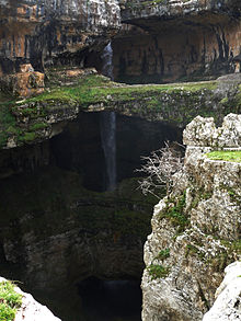
Baatara gorge waterfall
| Balaa gorge sinkhole | |
|---|---|
 | |
 | |
| Location | Tannourine, Lebanon |
| Coordinates | 34°10.406′N 35°52.222′E / 34.173433°N 35.870367°E |
| Type | Plunge |
| Number of drops | 1 |
| Longest drop | 90–100 m (300–330 ft) |
The Balaa gorge sinkhole (Baatara gorge waterfall) is a waterfall in the Tannourine, Lebanon[1] near Balaa.
The waterfall drops 255 metres (837 ft) into the Balaa Pothole, a cave of Jurassic limestone[2] located on the Lebanon Mountain Trail.[3] The cave is also known as the Cave of the Three Bridges.[4] Traveling from Laklouk to Tannourine one passes the village of Balaa, and the Three Bridges Chasm (in French Gouffre des Trois Ponts) is a five-minute journey into the valley below where one sees three natural bridges, rising one above the other and overhanging a chasm descending into Mount Lebanon. During the spring melt, a 90–100-metre (300–330 ft) cascade falls behind the three bridges and then down into the 240-metre (790 ft) chasm.[5]
Discovered to the western world in 1952 by French bio-speleologist Henri Coiffait,[6] the waterfall and accompanying sinkhole were fully mapped in the 1980s by the Spéléo club du Liban.[7] A 1988 fluorescent dye test demonstrated that the water emerged at the spring of Dalleh in Mgharet al-Ghaouaghir[8][9] (located near Balaa).[10]
References
- ^ 10 Most Beautiful Waterfalls of the World Archived 2010-03-16 at the Wayback Machine at Listphobia.com
- ^ "Balaa Pothole Lebanon". tourism-lebanon.com. Tourism Lebanon. Archived from the original on 2 February 2011. Retrieved 24 June 2010.
- ^ "The Lebanon Mountain Trail Project" (PDF). United States Agency for International Development. 10 June 2008. Retrieved 24 June 2010.
- ^ Courbon, Paul; Chabert, Claude; Bosted, Peter; Lindsley, Karen (1989). Atlas of the Great Caves of the World. Cave Books. p. 131. ISBN 978-0-939748-21-1.
- ^ "La région de Tannourine" (in French). LibanVision. Retrieved 2010-07-15.
De ses 240 mètres de hauteur ... C'est le plus impressionnant des trois, surtout que durant la saison de fonte des neiges, une cascade d'eau s'y forme, tombant en chute libre sur 90 mètres.
- ^ "Baatara Gorge – the Waterfall that Drops into a Cave". Retrieved 16 August 2011.
- ^ "Baatara Pothole". Heatheronhertravels.com. 13 March 2010. Retrieved 24 June 2010.
- ^ Abdul-Nour, Hani. "Ballouh Baatura, or The Three Bridges Chasm in Balaa". DiscoverLebanon.com. Retrieved 2010-07-15.
- ^ Carter, Terry; Dunston, Lara; Humphreys, Andrew (2004). Syria & Lebanon. Lonely Planet. pp. 291. ISBN 978-1-86450-333-3.
- ^ "Baatara Gorge Waterfall – Lebanon". FreshTravelDestinations.com. Retrieved February 14, 2016.
External links
- Balaa the 3 leveled waterfall - Photograph
- Gouffre de Balaa - Photograph
