
Carr's Tunnel
.jpg) Stereoscopic view of the tunnel | |
| Overview | |
|---|---|
| Location | Greensburg, Pennsylvania |
| Status | abandoned |
| Operation | |
| Constructed | rock bored, brick lined |
| Opened | January, 1856 |
| Owner | Pennsylvania Railroad |
| Technical | |
| Length | 825 feet |
| No. of tracks | double |
Carr's Tunnel is an abandoned railway tunnel in Greensburg, Pennsylvania. Known locally as Witches' Tunnel, it was originally built in 1856 for the Pennsylvania Railroad. It was brick-lined in 1868-1869.[1] The railway line it was associated with, now dismantled, once ran from Donohoe Station to the now-vanished Carney Station, near the Carney coal mine, and on to Latrobe.[2]
In recent years single-family residences have been built directly adjacent to the abandoned tunnel.[3]
External links
- Video of the tunnel [1]
Gallery
-
 Carr's Tunnel in 2013
 -
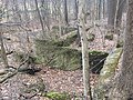 Remains of Carney Mine adjacent to Carr's Tunnel
_Tunnel_in_2013_01.JPG)

References
Wikimedia Commons has media related to Carr's Tunnel.
- ^ Gillette, Halbert Powers (1904). Rock Excavation, methods and cost (online book). New York: M.C. Clark. p. 338. Retrieved 2009-04-29.
- ^ "Carney Mine, Carney Station". Virtual Museum of Coal Mining in Western Pennsylvania. Archived from the original on 3 July 2015. Retrieved 9 November 2014.
- ^ "Former PRR mainline tunnel outside Greensburg". Pennsylvania Railroad Technical and Historical Society. Retrieved 10 November 2014.