
Search results
Did you mean: waterway
The page "Wasteway" does not exist. You can create a draft and submit it for review or request that a redirect be created, but consider checking the search results below to see whether the topic is already covered.
- canals Eastern Canal Hamilton Canal Lawrence Wasteway Massachusetts Wasteway Merrimack Canal Merrimack Wasteway Northern Canal Pawtucket Canal Western Canal...2 KB (136 words) - 19:46, 15 July 2024
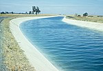 Delta-Mendota Canal, Volta Wasteway Crossing...14 KB (1,800 words) - 10:17, 24 August 2024
 Grant County, passing Grigg Farm Airport and crossing over the Winchester Wasteway, before ending at an intersection with SR 28 southwest of Ephrata. Every...7 KB (528 words) - 02:24, 31 July 2024
 "Wind River Irrigation Project, Lefthand Main Diversion and Lefthand Wasteway Check Structures", 8 photos, 7 data pages, 1 photo caption page HAER No...62 KB (7,084 words) - 19:50, 30 August 2024
 irrigation canals, and out into 3,500 miles (5,600 km) of drains and wasteways. The Grand Coulee Dam, powerplant, and various other parts of the CBP...19 KB (2,569 words) - 16:38, 23 May 2024
 powerhouse building was about 40 ft × 40 ft (12 m × 12 m). A concrete wasteway diverted water back into the canal when the turbines were not operating...23 KB (2,545 words) - 06:29, 15 March 2024
 before reaching the lake Crab Creek receives the waters of Rocky Coulee Wasteway, a mix of the intermittent Rocky Coulee Creek and irrigation runoff from...15 KB (1,609 words) - 14:59, 15 May 2024
 portion of the project for reuse in the southern portion. A system of wasteways has been built on both the West and East Low Canals to provide operational...2 KB (207 words) - 02:59, 4 May 2023
 Putah South Canal with a small terminal reservoir, and the necessary wasteways, laterals and drainage works. The Monticello Dam was constructed from...13 KB (1,512 words) - 13:51, 4 June 2024
 dam and empties into the creek. Just south of the spillway is a gated wasteway outlet controlled by one radial gate which empties into a short outlet...13 KB (1,176 words) - 11:55, 22 December 2023
 6 photos, 1 data page, 1 photo caption page HAER No. MA-4-B, "Hamilton Canal, Wasteway Gatehouse", 1 photo, 1 data page, 1 photo caption page HAER No. MA-5, "Western...9 KB (924 words) - 22:35, 7 August 2023
- Park Tyhee Lateral " Bannock ID canal Michaud 42.950°N 112.508°W Tyhee Wasteway " Bannock ID canal Pocatello North 42.962°N 112.465°W Tzum Point "painted...109 KB (145 words) - 21:07, 26 May 2024
 width from 100 feet (30 m) at its upper end to 30 feet (9.1 m) where its wasteway joins the Spicket River. The canal is trapezoidal in its cross-section...7 KB (798 words) - 17:47, 22 June 2024
 under I-82 and entering Kennewick, the East Fork is largely used as a wasteway for canals operated by the Kennewick Irrigation District (KID). It then...12 KB (1,185 words) - 12:38, 18 January 2022
- - 88 miles (142 km) Sub laterals length - 893 miles (1,437 km) Drains/wasteways length - 1,563 miles (2,515 km) Parcels of land served - 4,166 Number...5 KB (636 words) - 19:23, 12 January 2021
- Demolished Steel built-up girder 1910 2011 Union Pacific Railroad Sulphur Creek Wasteway Midvale Yakima 46°16′46″N 120°00′04″W / 46.27944°N 120.00111°W / 46...27 KB (114 words) - 19:52, 25 May 2024


- From waste + way. wasteway (plural wasteways) A chute or other route for the disposal of waste material.
- structures of stone. The essential features are a bulkhead, gates, and wasteway. Where there is a dam at the head of the canal, the headworks may be at