
Bourg-Saint-Bernard
Bourg-Saint-Bernard | |
|---|---|
 A general view of Bourg-Saint-Bernard | |
.svg) Coat of arms | |
Location of Bourg-Saint-Bernard  | |
 Bourg-Saint-Bernard  Bourg-Saint-Bernard | |
| Coordinates: 43°36′11″N 1°42′48″E / 43.6031°N 1.7133°E | |
| Country | France |
| Region | Occitania |
| Department | Haute-Garonne |
| Arrondissement | Toulouse |
| Canton | Revel |
| Government | |
| • Mayor (2008–2014) | Andrée Oriol |
| Area 1 | 16.6 km2 (6.4 sq mi) |
| Population (2021)[1] | 1,110 |
| • Density | 67/km2 (170/sq mi) |
| Time zone | UTC+01:00 (CET) |
| • Summer (DST) | UTC+02:00 (CEST) |
| INSEE/Postal code | 31082 /31570 |
| Elevation | 156–253 m (512–830 ft) (avg. 250 m or 820 ft) |
| 1 French Land Register data, which excludes lakes, ponds, glaciers > 1 km2 (0.386 sq mi or 247 acres) and river estuaries. | |
Bourg-Saint-Bernard (Languedocien: Le Borg de Sant Bernat) is a commune of the Haute-Garonne department in southwestern France.
Population
| Year | Pop. | ±% |
|---|---|---|
| 1962 | 590 | — |
| 1968 | 605 | +2.5% |
| 1975 | 585 | −3.3% |
| 1982 | 584 | −0.2% |
| 1990 | 659 | +12.8% |
| 1999 | 772 | +17.1% |
| 2008 | 841 | +8.9% |
Monument
-
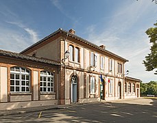 Town hall
 -
 Church "Saint-Bernard"
 -
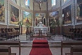 Altar
Altar -
 Font
Font -
 War memorial


See also
References
- ^ "Populations légales 2021". The National Institute of Statistics and Economic Studies. 28 December 2023.
Wikimedia Commons has media related to Bourg-Saint-Bernard.
| International | |
|---|---|
| National | |
| Other | |
This Haute-Garonne geographical article is a stub. You can help Wikipedia by expanding it. |