
Gilgit Valley
| Gilgit Valley | |
|---|---|
| وادی گلگت | |
 Gilgit Valley Location in Gilgit-Baltistan | |
| Floor elevation | 2,000 m (6,600 ft) |
| Geography | |
| Location | Gilgit District, Gilgit Baltistan, Pakistan |
| Population centers | Gilgit |
| Coordinates | 36°13′59″N 73°35′06″E / 36.233°N 73.585°E |
| Rivers | Gilgit River |
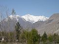
Gilgit Valley (Urdu: وادی گلگت) is a valley located in Gilgit District in Gilgit-Baltistan, northern Pakistan. The Gilgit River flows through the valley.[1] 375 km of road connects it to the town of Chitral via the Shandur Pass (3,800 m).
The town of Gilgit lies in the valley.[2]
-
 Gilgit Valley
 -
 Gilgit Valley
 -
 Gilgit Valley from Sonikot
 -
 Broad View Of Gilgit Valley


References
- ^ Negi, S. S. (2017-05-31). Discovering the Himalaya. Indus Publishing. p. 79. ISBN 9788173870798.
- ^ Brown, William (2014-11-30). Gilgit Rebelion: The Major Who Mutinied Over Partition of India. Pen and Sword. p. 4. ISBN 9781473821873.
This Gilgit-Baltistan location article is a stub. You can help Wikipedia by expanding it. |