
Paro, Bhutan
Paro
 | |
|---|---|
.jpg) Aerial view of Paro | |
 Paro Location in Bhutan | |
| Coordinates: 27°26′N 89°25′E / 27.433°N 89.417°E | |
| Country | |
| District | Paro District |
| Gewog | Wangchang Gewog |
| Thromde | Paro |
| Elevation ་ at Paro Airport | 2,200 m (7,200 ft) |
| Population (2017) | |
| • Total | 11,448 |
| Time zone | UTC+6 (BTT) |
| Area code | +975-8 |
| Climate | Cwb |
Paro (Dzongkha: སྤ་རོ་) is a town and seat of Paro District, in the Paro Valley of Bhutan.[1] It is a historic town with many sacred sites and historical buildings scattered throughout the area. It is also home to Paro Airport, Bhutan's sole international airport.
Architecture
The main street has many examples of traditionally decorated buildings.[2]
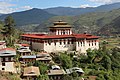
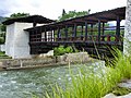
The Dungtse Lhakhang (a 15th-century temple) and the Ugyen Perli Palace are near the new bridge. Members of royal family lodge in the palace when in Paro.[2] Nearby is the old bridge and the Rinpung Dzong. Notable hotels include the Olathang Hotel built in an ornate style.[2]
About 10 kilometres (6 miles) outside Paro is the famous Paro Taktsang (Tiger's Nest) Buddhist monastery and hermitage. Some Bhutanese believe that Padmasambhava (Guru Rinpoche) flew on the back of a tigress to this location from Tibet.[3] The trek to Tiger's Nest monastery takes about three hours one way. A scenic view of the town of Paro can be seen from the Tiger's Nest.[2] A 16-kilometre (10-mile) road passes up the valley to the ruins of another fortress-monastery, Drukyel Dzong, which was partly destroyed by fire in 1951.[2]
Paro is home to Bhutan's tallest building, the Ta-Dzhong, which is 22 meters (72 feet) high, and has 6 floors. It was completed in 1649.[4]
Airport
Paro Airport has been described as "the most difficult commercial airport in the world",[5] The airport has only one runway. Airplanes on approach pass by 5,500m Himalayan mountain peaks, and the 1,980m runway length presents a double challenge, due to the extremely high density altitude at the site. As a result, only a handful of airline pilots (8 as of December 2014) are certified to operate commercial aeroplanes there. About 30,000 persons arrive at the airport each year.
Gallery
-
 A street in Paro
 -
 Shops in Paro
 -

-
-

-

-


References
- ^ National Geospatial Intelligence Agency
- ^ a b c d e "In The Kingdom Of Bhutan". Global Sapiens. 6 October 2002. Retrieved 11 July 2008.
- ^ Pommaret, Francoise (2006). Bhutan Himalayan Mountains Kingdom (5th edition). Odyssey Books and Guides. pp. 136–7.
- ^ https://www.emporis.com/statistics/tallest-buildings/country/100020/bhutan
- ^ [1] Paro Airport, atlas obscura (website), accessed 3 December 2014
External links
 Paro travel guide from Wikivoyage
| International | |
|---|---|
| National | |