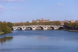
Pont Neuf, Toulouse
Pont Neuf, Toulouse | |
|---|---|
 Pont Neuf, Toulouse | |
| Coordinates | 43°35′58″N 1°26′19″E / 43.599307°N 1.438724°E |
| Crosses | Garonne River |
| Locale | Toulouse |
| Official name | Pont de Pierre[1] |
| Characteristics | |
| Design | arch bridge |
| Material | Stone |
| Longest span | approximately 30 metres (98 ft)[2] |
| No. of spans | 7[2] |
| History | |
| Designer | Jacques Le Mercier (Lemercier) Pierre Souffron[2] |
| Construction start | 1544[2] |
| Construction end | 1632[2] |
| Location | |
 | |
The Pont Neuf, French for "New Bridge" (a.k.a. Pont de Pierre and Grand Pont),[1] is a 16th-century bridge in Toulouse, in the South of France.
Construction
Original planning for the bridge started in 1542 by the assembly of a committee of master masons and carpenters. Construction started on the foundations in 1544;[2] the first arch was started in 1614.[1] The bridge was finished in 1632, and was inaugurated on 19 October 1659.
The bridge is not symmetrical; the longest arch is the third from the right-hand bank. The openings through the piers were originally supposed to represent the face and mane of a lion.[1] A triumphal archway added in 1686 constricted traffic and was removed in 1860.[1]
It is 220m long[citation needed], and has 7 arches.
References
See also
External links
Wikimedia Commons has media related to Pont Neuf.
Wikimedia Commons has media related to Pont-Neuf de Toulouse.
