
Saint-Pierre, Haute-Garonne
Saint-Pierre | |
|---|---|
_-_L%27%C3%A9glise_Saint-Martin.jpg) The church in Saint-Pierre | |
.svg) Coat of arms | |
Location of Saint-Pierre  | |
 Saint-Pierre  Saint-Pierre | |
| Coordinates: 43°37′56″N 1°39′03″E / 43.6322°N 1.6508°E | |
| Country | France |
| Region | Occitania |
| Department | Haute-Garonne |
| Arrondissement | Toulouse |
| Canton | Pechbonnieu |
| Intercommunality | Coteaux du Girou |
| Government | |
| • Mayor (2008–2014) | Joël Bouche |
| Area 1 | 4.74 km2 (1.83 sq mi) |
| Population (2021)[1] | 254 |
| • Density | 54/km2 (140/sq mi) |
| Time zone | UTC+01:00 (CET) |
| • Summer (DST) | UTC+02:00 (CEST) |
| INSEE/Postal code | 31511 /31590 |
| Elevation | 150–232 m (492–761 ft) (avg. 218 m or 715 ft) |
| 1 French Land Register data, which excludes lakes, ponds, glaciers > 1 km2 (0.386 sq mi or 247 acres) and river estuaries. | |
Saint-Pierre is a commune in the Haute-Garonne department in southwestern France.
Population
| Year | Pop. | ±% |
|---|---|---|
| 1881 | 196 | — |
| 1962 | 126 | −35.7% |
| 1968 | 134 | +6.3% |
| 1975 | 115 | −14.2% |
| 1982 | 135 | +17.4% |
| 1990 | 201 | +48.9% |
| 1999 | 209 | +4.0% |
| 2008 | 248 | +18.7% |
Monuments
-
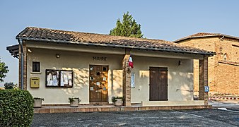 Town hall
 -
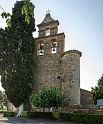 Church st.-Martin bell gable
 -
 War memorial
_-_La_mairie.jpg)
_-_L%27%C3%A9glise_Saint-Martin_-_Clocher-mur.jpg)
_-_Monument_aux_morts.jpg)
See also
References
- ^ "Populations légales 2021". The National Institute of Statistics and Economic Studies. 28 December 2023.
Wikimedia Commons has media related to Saint-Pierre (Haute-Garonne).
| Authority control databases: National |
|---|
This Haute-Garonne geographical article is a stub. You can help Wikipedia by expanding it. |