
Steenwijk
Steenwijk, Overijssel, Netherlands | |
|---|---|
City | |
 Bastion in the fortifications around the old city | |
.svg) Coat of arms | |
| Coordinates: 52°47′20″N 6°7′36″E / 52.78889°N 6.12667°E | |
| Country | Netherlands |
| Province | Overijssel |
| Municipality | Steenwijkerland |
| Population (1 January 2007) | 18.655 |
Steenwijk (Low German: Steenwiek, Stienwiek English:Stenwick) is a city in the Dutch province of Overijssel. It is located in the municipality of Steenwijkerland. It is the largest town of the municipality.
Steenwijk received city rights in 1327. In the Eighty Years' War (1568–1648) it was conquered by the Spaniards in 1581, but regained by the Dutch in 1592.
Steenwijk was a separate municipality until 2001, when it merged with Brederwiede and IJsselham. The new municipality was first named "Steenwijk", but was renamed in 2003 to "Steenwijkerland".[1]
Transport
Railway Station: Steenwijk
Gallery
-
 View on the city centre from the St Clemens tower.
 -
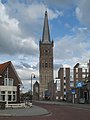 church: de Grote of Sint Clementuskerk
 -
 Church: de Clemenskerk
 -
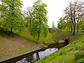 Fortifications with gate around the old city of Steenwijk.
 -
 Art Nouveau villa Rams Woerthe.


References
- ^ Ad van der Meer and Onno Boonstra, Repertorium van Nederlandse gemeenten, KNAW, 2011.
External links
Wikimedia Commons has media related to Steenwijk.
- Template:Kuyper Map of the former municipality, around 1868.
52°47′N 6°07′E / 52.783°N 6.117°E
This Overijssel location article is a stub. You can help Wikipedia by expanding it. |