Actium

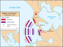
Actium (modern name: Punta) was the ancient name of a promontory of western Greece in northwestern Acarnania, at the mouth of the Sinus Ambracius (Gulf of Arta) opposite Nicopolis, built by Augustus on the north side of the strait.
On the promontory was an ancient temple of Apollo Actius, which was enlarged by Augustus, who, to memorialize the Battle of Actium, instituted or renewed the quinquennial games known as Actia or Ludi Actiaci. Actiaca Aera was a computation of time from the battle. There was on the promontory a small town, or rather village, also called Actium.
History
Actium belonged originally to the Corinthian colonists of Anactorium, who probably founded the worship of Apollo Actius and the Actia games; in the 3rd century BC it fell to the Acarnanians, who subsequently held their synods there. Actium is chiefly famous as the site of Octavian's decisive victory over Mark Antony (September 2, 31 BC). This battle ended a long series of ineffectual operations. The final conflict was provoked by Antony, who is said to have been persuaded by his lover, the queen Cleopatra of Egypt, to retire to her land and give battle to mask his retreat; but lack of provisions and the growing demoralization of his army would eventually account for this decision. An ancient Roman festival, Actia, was named after Actium.
