Airway (aviation)
This article needs additional citations for verification. (February 2014) |

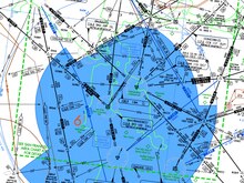
An airway is a legally defined corridor that connects one specified location to another at a specified altitude, along which an aircraft that meets the requirements of the airway may be flown.[1][2][3][4] Airways are defined with segments within a specific altitude block, corridor width, and between fixed geographic coordinates for satellite navigation systems, or between ground-based radio transmitter navigational aids (navaids) (such as VORs or NDBs) or the intersection of specific radials of two navaids.
United States
To guide airmail pilots on their delivery routes, the United States Postal Service constructed the first airways in the United States. These airways were between major cities and identified at night by a series of flashing lights and beacons which pilots flew over in sequence to get from one city to the next.[citation needed] However, these visual airways required the pilots to be in visual contact with the ground which precluded flying in fog or clouds. Subsequently, the Department of Commerce funded the development of other means of airway navigation.[5]
The first airways to be delineated by radiofrequency were based on the old A-N system. The pilot listened for the stronger of the Morse codes transmitters ("· –" for A and "– ·" for N) (indicating left or right of the course); the objective was to be centered on course hearing a steady tone (the A and N Morse codes merge to form a steady tone when the receiver is equidistant from both transmitters).
Later airways were based on low / medium frequency ground stations, like the beat frequency oscillator (BFO) and the non-directional beacon (NDB). These L/M frequency airways were the colored airways. Colored airways still exist, mostly in Alaska. There are only a few colored airways remaining in the contiguous United States. There is one colored airway off the coast of North Carolina called G13 (Green 13). Additionally, there are several colored airways connecting to, and transitioning through, the Florida Keys. B9 (Blue 9) connects the Southern Florida mainland to Marathon Key. B646 (Blue 646) connects Mérida, Mexico to Nassau, Bahamas and transitions through the Florida keys. A portion of B646 connects Key West to Marathon Key and serves as a bypass for aircraft unable to meet the 14,500 minimum altitude along V3. Finally, G448 (Green 448), which begins at the Marathon NDB, is the only low-altitude airway that connects the United States to Cuba; the airway continues through Cuba to the Grand Cayman and terminates at San Andres.
Low altitude airways (below 18,000 feet (5,500 m) MSL) that are based on VOR stations, appear on sectional charts, world aeronautical charts, and en route low altitude charts and are designated with the prefix "V" (pronounced victor, hence, victor airways, q.v.). High altitude airways (from 18,000 feet (5,500 m) MSL to FL450) based on VOR stations are called jet routes; they appear on high altitude charts (that usually don't show topography, as the low altitude charts do) and are prefixed by the letter "J".
With the invention of RNAV routes, airway structure no longer has to be based on ground-based navaids; a new naming convention is used. RNAV routes not based on VOR routes in low altitudes are preceded with the letter "T"; high airway routes are designated with the letter "Q". RNAV routes are blue on low and high en route charts produced by FAA's Aeronautical Navigation Products (AeroNav Products).
Europe
Airways are corridors 10 nautical miles (19 km) wide of controlled airspace with a defined lower base, usually FL070–FL100, extending to FL195. They link major airports giving protection to IFR flights during the climb and descent phases, and often for non-jet aircraft, cruise phase of flight. Historically, they were laid out between VORs; however, advances in navigational technology mean that this is no longer a necessity. Each airway has a designator containing one letter and one to three numbers. All airspace above FL195 is class C controlled airspace, the equivalent to airways being called Upper Air Routes and having designators prefixed with the letter "U". If an upper air route follows the same track as an airway, its designator is the letter "U" prefix and the designator of the underlying airway.
In the UK, airways are all class A below FL195 and therefore VFR flights are prohibited.
Air corridor
An air corridor is a designated region of airspace that an aircraft must remain in during its transit through a given region. Air corridors are typically imposed by military or diplomatic requirements. During the Berlin Blockade, for example, pilots flying across Soviet-controlled German airspace were required to maintain very specific positioning within air corridors defined by the commander in charge of the airlift. Subsequent flights, both military and civilian, between West Germany and West Berlin during the Cold War were required to remain within their designated corridor or risk being shot down.
Air corridors should not be confused with airways. Airways are navigational aids which a pilot generally may deviate from when circumstances warrant, while compliance with a designated air corridor is mandatory.
See also
References
- ^ Gunston, Bill (2004). The Cambridge Aerospace Dictionary Cambridge. Cambridge University Press. p. 34. ISBN 978-0521841405.
- ^ FAA regulations 5-3-4. Airways and Route Systems
- ^ Airway (definition)
- ^ The term airway is used by aviation professionals including ICAO, but other terms have been used or misused by non-specialist sources, sometimes to mean the same thing.
- ^ "The Evolution of Airway Lights and Electronic Navigation Aids". Centennialofflight.net. 1924-07-01. Retrieved 2014-07-28.
