Albert Canal


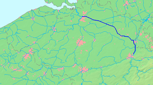
The Albert Canal (Dutch: Albertkanaal, French: Canal Albert) is a canal located in northeastern Belgium, named after King Albert I of Belgium. It connects the major cities Antwerp and Liège and the Meuse and Scheldt rivers. It has a depth of 3.4 metres (11 ft), a free height of 6.7 metres (22 ft) and a total length of 129.5 kilometres (80.5 mi). The maximum capacity is a barge of 10,000 tons.
Between Antwerp and Liège, there is a height difference of 56 metres (184 ft), and a total of 6 canal locks were needed to overcome the difference in elevation. Five canal locks each have a height difference of 10 metres (33 ft), located in Genk, Diepenbeek, Hasselt, Kwaadmechelen and Olen, while the canal lock at Wijnegem has a height difference of 5.45 metres (17.9 ft).
In the 1930s, it took about 7 days to travel from Antwerp to Liege over water. These days the same distance is covered in 18 hours. Since the completion of the Rhine-Main-Danube Canal in 1992, a barge can now travel from Antwerp all the way across Europe to the Black Sea.
History

The Albert Canal was dug from 1930-1939. The German construction firm Hochtief AG worked on the canal between 1930 and 1934. It was used for the first time in 1940, but because of World War II, serious use only began in 1946.
During the Second World War the canal functioned as a defense line. It had to secure not only Belgium but also the northeastern arrondissements of France. The canal locks were used to control the water level. In September 1944, the Second Canadian Division forged a bridgehead across the canal as the Allies fought to liberate Belgium and The Netherlands from Nazi occupation.
