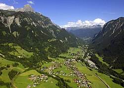
Alfenz
This article has multiple issues. Please help improve it or discuss these issues on the talk page. (Learn how and when to remove these messages)
|
| Alfenz | |
|---|---|
 The Alfenz is the main river of the Klostertal. It separates the Northern Limestone Alps (left/north) from the Silvretta Crystalline (right/south) | |
 | |
| Location | |
| Country | Austria |
| Physical characteristics | |
| Source | |
| • location | Schindler Spitze |
| • elevation | 2,640 m (8,660 ft) |
| Mouth | |
• location | Ill |
• coordinates | 47°08′06″N 9°50′13″E / 47.1349°N 9.8370°E |
| Length | ~ 26 km (16 mi) |
| Basin features | |
| Progression | Ill→ Rhine→ North Sea |
The Alfenz river is approximately 26 kilometres long and is the largest river in the Klostertal in Austria. The river originates at the Schindler Spitze (2,640 metres above sea level) and flows west. The river's flow created the Klostertal valley. The Alfenz merges with the Ill at a point 3.5 km east of Bludenz.
Villages near the river include Klösterle and Dalaas. The A14 motorway to Feldkirch runs alongside the river.
The spring of the Alfenz is close to the European Watershed. The Alfenz belongs to the Rhein watershed, while across the Arlberg to the east the water flows into the Danube. The Alfenz carries rocks from the Northern Limestone Alps that crop out north of the river and the Silvretta Crystalline which crops out in the south.
References
