Jump to content

Araponga

Coordinates: 20°40′01″S 42°31′15″W / 20.66694°S 42.52083°W / -20.66694; -42.52083
From Wikipedia, the free encyclopedia

This is an old revision of this page, as edited by Nihiltres (talk | contribs) at 04:45, 9 May 2016 (Simplified hatnote syntax using AWB). The present address (URL) is a permanent link to this revision, which may differ significantly from the current revision.

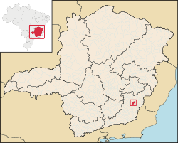
Location of Araponga within Minas Gerais

Araponga is a Brazilian municipality located in the state of Minas Gerais. Its population as of 2006 is estimated to be 7,947 people living in an altitude of 1,040 meters. The area of the municipality is 304.421 km². The city belongs to the mesoregion of Zona da Mata and to the microregion of Viçosa.

See also

20°40′01″S 42°31′15″W / 20.66694°S 42.52083°W / -20.66694; -42.52083