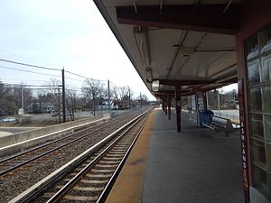
Ashland station (PATCO)
ASHLAND | |||||||||||
|---|---|---|---|---|---|---|---|---|---|---|---|
| PATCO rapid transit station | |||||||||||
 Ashland station platform in April 2015 | |||||||||||
| General information | |||||||||||
| Location | 2 Burnt Mill Road Voorhees, New Jersey | ||||||||||
| Coordinates | 39°51′31″N 75°00′33″W / 39.85856°N 75.00920°W | ||||||||||
| Owned by | Delaware River Port Authority | ||||||||||
| Line(s) | Lua error in Module:Adjacent_stations at line 430: "title" is missing from the data page. | ||||||||||
| Platforms | 1 island platform | ||||||||||
| Tracks | 2 (PATCO), 1 (Atlantic City Line) | ||||||||||
| Construction | |||||||||||
| Parking | 1041 spaces | ||||||||||
| Bicycle facilities | Yes | ||||||||||
| History | |||||||||||
| Opened | February 15, 1969[1] | ||||||||||
| Electrified | 750 volts DC (PATCO only) | ||||||||||
| Services | |||||||||||
| |||||||||||
Ashland is a rapid transit station on the PATCO Lindenwold Line. The station is located in Voorhees, New Jersey, roughly near the intersection of Evesham and Burnt Mill Roads. A small section of the parking area is located in Cherry Hill. Ashland station is located near, but not immediately adjacent to, Voorhees Town Center.
Station layout
Ashland is a two-level station. The ticketing and fare control are located on the lower level, which is below parking lot level.
| P Platform level |
NJ Transit | ← Atlantic City Line does not stop here → |
| PATCO westbound | ← Lindenwold Line toward Philadelphia (Woodcrest) | |
| Island platform, doors will open on the left, right | ||
| PATCO eastbound | → Lindenwold Line toward Lindenwold (Terminus) → | |
| G | Street Level | Entrances/Exits |
References
- ^ Baisden, Cheryl L. (2009). Images of America: Delaware River Port Authority. Mount Pleasant, South Carolina: Arcadia Publishing. p. 110. ISBN 9780738565811.
External links
 Media related to Ashland station (PATCO) at Wikimedia Commons
- Ashland (PATCO)
- Station from Google Maps Street View

