
Augrabies Falls
| Augrabies Falls | |
|---|---|
 Augrabies Falls | |
 | |
| Location | Northern Cape, South Africa |
| Coordinates | 28°35′29″S 20°20′27″E / 28.59139°S 20.34083°E |
| Type | Cascade |
| Total height | 56 metres (183 ft) |
| Average width | 24 metres (80 ft) |
| Watercourse | Orange River |
| Average flow rate | 313 cubic metres (11,050 cu ft) |
The Augrabies Falls /ɔːˈxrɑːbiːz/ is a waterfall on the Orange River, South Africa, within the Augrabies Falls National Park. The falls are around 60 metres (200 ft) in height. The original Khoikhoi residents named the waterfall "Ankoerebis" — "place of big noises" — from which the Trek Boers, who settled here later on, derived the name, "Augrabies".
The falls have recorded 7,800 cubic metres (280,000 cu ft) of water every second in floods in 1988 (and 6,800 cubic metres (240,000 cu ft) in the floods of 2006). This is over three times the average high season flow rate of Niagara Falls of 2,400 cubic metres (85,000 cu ft) per second, more than four times Niagara's annual average, and greater than Niagara's all-time record of 6,800 cubic metres (240,000 cu ft) per second.
The gorge at the Augrabies Falls is 240 metres (800 ft) deep and 18 kilometres (10 mi) long, and is an impressive example of granite erosion.
- Augrabies Falls
-
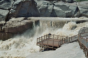
 The waterfall from the viewing platform
 -
 Augrabies Falls during the dry season
 -
 The waterfall in flood


See also
References
"Augrabies Falls in the World Waterfall Database". Retrieved 2009-05-19.
External links
This Northern Cape location article is a stub. You can help Wikipedia by expanding it. |