
Bach an der Donau
Bach a.d.Donau | |
|---|---|
 Coat of arms | |
Location of Bach a.d.Donau within Regensburg district 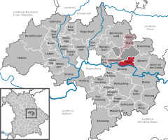 | |
 Bach a.d.Donau  Bach a.d.Donau | |
| Coordinates: 49°1′15″N 12°18′14″E / 49.02083°N 12.30389°E | |
| Country | Germany |
| State | Bavaria |
| Admin. region | Oberpfalz |
| District | Regensburg |
| Municipal assoc. | Donaustauf |
| Subdivisions | 3 Ortsteile |
| Government | |
| • Mayor | Josef Peutler (CBV) |
| Area | |
| • Total | 14.82 km2 (5.72 sq mi) |
| Elevation | 334 m (1,096 ft) |
| Population (2022-12-31)[1] | |
| • Total | 1,825 |
| • Density | 120/km2 (320/sq mi) |
| Time zone | UTC+01:00 (CET) |
| • Summer (DST) | UTC+02:00 (CEST) |
| Postal codes | 93090 |
| Dialling codes | 09403 |
| Vehicle registration | R |
| Website | www.bach-donau.de |
Bach is a municipality in the district of Regensburg in Bavaria in Germany.
References
- ^ Genesis Online-Datenbank des Bayerischen Landesamtes für Statistik Tabelle 12411-003r Fortschreibung des Bevölkerungsstandes: Gemeinden, Stichtag (Einwohnerzahlen auf Grundlage des Zensus 2011) (Hilfe dazu).

| International | |
|---|---|
| National | |
This Regensburg district location article is a stub. You can help Wikipedia by expanding it. |