Backaland
Appearance
| Backaland | |
|---|---|
 A farm overlooking the Bay of Backaland, Eday | |
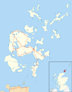
Location within Orkney | |
| OS grid reference | HY565302 |
| Civil parish | |
| Council area | |
| Lieutenancy area | |
| Country | Scotland |
| Sovereign state | United Kingdom |
| Post town | ORKNEY |
| Postcode district | KW17 |
| Dialling code | 01856 |
| Police | Scotland |
| Fire | Scottish |
| Ambulance | Scottish |
| UK Parliament | |
| Scottish Parliament | |
Backaland is a settlement on the island of Eday in Orkney, Scotland. The settlement is also within the parish of Eday,[1] and it is located to the south west of the island.[2] Backaland is situated at the southern end of the B9063.[3]
References
- ^ "Details of Backaland". Gazetteer for Scotland. Retrieved 1 January 2015.
- ^ "Get-a-map". Ordnance Survey. Retrieved 26 Feb 2012.
- ^ "B9063". Sabre. Retrieved 1 January 2015.
External links
Wikimedia Commons has media related to Backaland.

