
Bad Rodach
Bad Rodach | |
|---|---|
 Town hall | |
 Coat of arms | |
Location of Bad Rodach within Coburg district 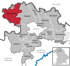 | |
| Country | Germany |
| State | Bavaria |
| Admin. region | Oberfranken |
| District | Coburg |
| Subdivisions | 14 districts |
| Government | |
| • Mayor | Gerold Strobel (FW) |
| Area | |
| • Total | 77.65 km2 (29.98 sq mi) |
| Elevation | 320 m (1,050 ft) |
| Population (2022-12-31)[1] | |
| • Total | 6,606 |
| • Density | 85/km2 (220/sq mi) |
| Time zone | UTC+01:00 (CET) |
| • Summer (DST) | UTC+02:00 (CEST) |
| Postal codes | 96476 |
| Dialling codes | 09564 |
| Vehicle registration | CO |
| Website | www.bad-rodach.de |
Bad Rodach is a town in the district of Coburg, in Upper Franconia, a north Bavarian Regierungsbezirk, Germany. It is situated 10 km southeast of Hildburghausen, and 17 km northwest of Coburg. Since 1999 the city has been a spa-resort and is reported to have the warmest thermal spring in the North of Bavaria.
Description
Bad Rodach is in Upper Franconia, in the District of Coburg approximately 17 km northwest of Coburg. It is situated among the Lange Berge and Gleichberge mountain ranges. The river Rodach crosses through the town.
The town is composed of the following boroughs:
|
|
|
|
Wikimedia Commons has media related to Bad Rodach.
Towns and municipalities in Coburg (district) | ||
|---|---|---|
 | ||
References
- ^ Genesis Online-Datenbank des Bayerischen Landesamtes für Statistik Tabelle 12411-003r Fortschreibung des Bevölkerungsstandes: Gemeinden, Stichtag (Einwohnerzahlen auf Grundlage des Zensus 2011) (Hilfe dazu).
This Coburg district location article is a stub. You can help Wikipedia by expanding it. |