
Patara, Nagorno-Karabakh
Patara / Badara
Պատարա / Բադարա | |
|---|---|
 | |
 Patara / Badara  Patara / Badara | |
| Coordinates: 39°55′18″N 46°39′43″E / 39.92167°N 46.66194°E | |
| Country | |
| • District | Khojaly |
| Elevation | 890 m (2,920 ft) |
| Population (2015)[1] | |
| • Total | 815 |
| Time zone | UTC+4 (AZT) |
Patara (Armenian: Պատարա) or Badara (Armenian: Բադարա) is a village in the Khojaly District of Azerbaijan. The village has an ethnic Armenian-majority population, and also had an Armenian majority in 1989.[2] Prior to the 2023 Azerbaijani offensive, it was de facto controlled by the Republic of Artsakh.[3]
Toponymy
[edit]The village was historically known as Ptretsik (Armenian: Պտրեցիկ).
History
[edit].jpg)
During the Soviet period, the village was a part of the Askeran District of the Nagorno-Karabakh Autonomous Oblast.
After the 2020 Nagorno-Karabakh war, Artsakh launched the construction of a new settlement for IDPs in the area between Patara and the neighboring village of Astghashen, for people displaced from the villages of Sghnakh, Jraghatsner, Madatashen and Moshkhmhat in the Askeran Province.[4][5][6] The village was heavily bombarded during the Second Nagorno-Karabakh War, and much of its territory is littered with unexploded ammunition.[7]
Historical heritage sites
[edit]Historical heritage sites in and around the village include the small chapel of Drbasut Yeghtsi (Armenian: Դրբասուտ Եղցի), a cemetery from between the 9th and 13th centuries, a village, cemetery, and khachkar from between the 10th and 13th centuries, a 12th/13th-century fortress, the church of Tsera Nahatak (Armenian: Ծերա Նահատակ) built in 1326, the 12th/13th-century monastery of Okhty Yeghtsi (Armenian: Օխտը Եղցի), the 12th/13th-century monastery of Otskavank (Armenian: Օծկավանք), the 13th-century church of Surb Amenaprkich (Armenian: Սուրբ Ամենափրկիչ, lit. 'Holy Savior'), the restored three-nave St. Stephen's Church (Armenian: Սուրբ Ստեփանոս եկեղեցի, romanized: Surb Stepanos Yekeghetsi) built in 1870, and a 19th-century watermill.[1][8]
Economy and culture
[edit]The population is mainly engaged in agriculture and animal husbandry. As of 2015, the village has a municipal building, a secondary school, a house of culture, two shops, and a medical centre.[1]
Demographics
[edit]The village had 849 inhabitants in 2005,[9] and 815 inhabitants in 2015.[1]
Gallery
[edit]-
 St. Stephen's Church, built in 1870
 -
 Religious shrine
 -
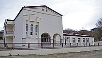 Municipal building
 -
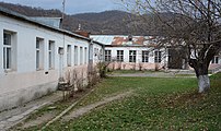 Village school
 -
 Vodka production in the village
 -
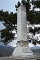
 A monument to victims of the Nagorno-Karabakh conflict
 -
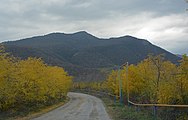 Scenery
 -
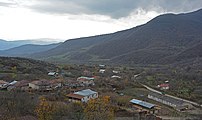 Panorama
 -
 Monument
 -
 The 12th/13th-century Okhty Yeghtsi Monastery


References
[edit]- ^ a b c d Hakob Ghahramanyan. "Directory of socio-economic characteristics of NKR administrative-territorial units (2015)".
- ^ Андрей Зубов. "Андрей Зубов. Карабах: Мир и Война". drugoivzgliad.com.
- ^ Nagorno-Karabakh’s breakaway government says it will dissolve itself, The Guardian, 28 Sep 2023, retrieved on 14 Nov 2023
- ^ Armenpress (2021-02-16). "Construction of new residential settlement for displaced citizens launched in Artsakh".
- ^ Siranush Ghazanchyan (2021-02-13). "New settlement being established in Artsakh's Askeran region". Public Radio of Armenia.
- ^ Tirayr Muradyan & Saro Baghdasaryan (2021-07-12). "New Artsakh Village to House IDPs". hetq.am.
- ^ "Nagorny Karabakh's Female Deminers". iwpr.net. Retrieved 2023-03-12.
- ^ Kiesling, Brady; Kojian, Raffi (2019). Rediscovering Armenia: An in-depth inventory of villages and monuments in Armenia and Artsakh (3rd ed.). Armeniapedia Publishing.
- ^ "The Results of the 2005 Census of the Nagorno-Karabakh Republic" (PDF). National Statistic Service of the Republic of Artsakh.
External links
[edit]Capital: Askeran | ||
| Urban communities |  | |
| Rural communities |
| |
| Not under Artsakh control | ||
