Bagana
| Bagana | |
|---|---|
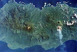
 An ash plume originating from Bagana at right, just below the dark-colored caldera lake of Billy Mitchell | |
| Highest point | |
| Elevation | 1,750 m (5,740 ft) |
| Coordinates | 6°08′24″S 155°11′42″E / 6.140°S 155.195°E |
| Geography | |
| Location | Bougainville, Papua New Guinea |
| Parent range | Emperor Range |
| Geology | |
| Mountain type | Lava cone |
| Last eruption | 2000 to 2015 (ongoing)[1] |
Bagana is an active volcano located in the centre of the island of Bougainville, Papua New Guinea, the largest island of the Solomon group. It is the most active volcano in the country.
Just north-east of Bagana is the volcano crater lake Billy Mitchell. Bagana is one of 17 post-Miocene strato volcanos on Bougainville.[2] U.S. General Floyd L. Parks flew over the Solomon Islands on 27 October 1948 and witnessed the eruption of Bagana. His photographs of Bagana erupting were published in Life magazine.[3]
See also
References
- ^ "Bagana". Global Volcanism Program. Smithsonian Institution.
- ^ Blake, D.H., "Post miocene volcanoes on Bougainville Island, territory of Papua and New Guinea", Bulletin of Volcanology 1968, Vol. 32(1):121–138, retrieved 27 February 2010
- ^ "Volcano erupts", Life Magazine, p. 42, 29 November 1948, retrieved 27 February 2010
