Balsas, Maranhão
Balsas | |
|---|---|
Municipality | |
| The Municipality of Balsas | |
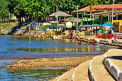
 The Das Balsas River, a popular tourist attraction in Balsas | |
| Nicknames: "Bls", "Balsinhas de Açúcar", "Princesinha do Sul do Maranhão", "Capital da Agricultura e da Lavoura Mecanizada" ("Bls", "Little Sugar Ferries", "Little Princess of Southern Maranhão", "Capital of the Mechanized Agriculture") | |
 Location of Balsas in the State of Maranhão | |
| Coordinates: 07°31′38″S 46°02′39″W / 7.52722°S 46.04417°W | |
| Country | Brazil |
| Region | Northeast |
| State | Maranhão |
| Founded | March 22, 1918 |
| Government | |
| • Mayor | Erik Augusto Costa e SilvaPDT) |
| Area | |
| • Total | 13,141.637 km2 (5,074.014 sq mi) |
| [1] | |
| Elevation | 283 m (928 ft) |
| Population (2022 [2]) | |
| • Total | 107,767 |
| • Density | 8.2/km2 (21/sq mi) |
| Time zone | UTC−3 (BRT) |
| HDI (2000) | 0.696 – medium[3] |
| Website | www.balsas.ma.gov.br |
Balsas (Portuguese pronunciation: [ˈbawsɐs]) is a city in the state of Maranhão, northeast Brazil. It is located in southern Maranhão, 800 km from the capital of the state, São Luís.
Geography
[edit]Balsas covers an area of 13,141.64 km2, being the largest municipality in Maranhão. The median elevation of the city is 283 meters (810 ft).
Climate
[edit]Balsas has a Savanna tropical climate. Temperature is hot from April through October. It rains from November through March.
| Climate data for Balsas (1981–2010) | |||||||||||||
|---|---|---|---|---|---|---|---|---|---|---|---|---|---|
| Month | Jan | Feb | Mar | Apr | May | Jun | Jul | Aug | Sep | Oct | Nov | Dec | Year |
| Mean daily maximum °C (°F) | 31.0 (87.8) |
31.2 (88.2) |
31.2 (88.2) |
31.6 (88.9) |
32.4 (90.3) |
32.9 (91.2) |
33.3 (91.9) |
34.8 (94.6) |
35.4 (95.7) |
33.9 (93.0) |
32.2 (90.0) |
31.0 (87.8) |
32.6 (90.7) |
| Daily mean °C (°F) | 25.8 (78.4) |
25.9 (78.6) |
25.9 (78.6) |
26.4 (79.5) |
26.6 (79.9) |
26.3 (79.3) |
26.2 (79.2) |
27.5 (81.5) |
28.8 (83.8) |
28.1 (82.6) |
26.8 (80.2) |
26.0 (78.8) |
26.7 (80.1) |
| Mean daily minimum °C (°F) | 21.9 (71.4) |
22.0 (71.6) |
22.2 (72.0) |
22.5 (72.5) |
21.8 (71.2) |
20.4 (68.7) |
19.4 (66.9) |
20.2 (68.4) |
22.2 (72.0) |
22.8 (73.0) |
22.3 (72.1) |
22.0 (71.6) |
21.6 (70.9) |
| Average precipitation mm (inches) | 195.9 (7.71) |
178.9 (7.04) |
206.0 (8.11) |
134.8 (5.31) |
46.0 (1.81) |
4.0 (0.16) |
2.3 (0.09) |
4.2 (0.17) |
27.6 (1.09) |
98.0 (3.86) |
133.1 (5.24) |
201.7 (7.94) |
1,232.5 (48.52) |
| Average precipitation days (≥ 1.0 mm) | 12 | 12 | 14 | 11 | 4 | 1 | 0 | 1 | 2 | 7 | 9 | 12 | 85 |
| Average relative humidity (%) | 80.5 | 80.4 | 80.9 | 78.0 | 71.4 | 61.4 | 52.7 | 47.9 | 49.5 | 62.5 | 73.6 | 79.1 | 68.2 |
| Mean monthly sunshine hours | 148.9 | 137.4 | 154.9 | 184.9 | 238.8 | 268.5 | 289.1 | 294.4 | 254.0 | 191.5 | 149.6 | 132.0 | 2,444 |
| Source: Instituto Nacional de Meteorologia[4] | |||||||||||||
Vegetation
[edit]Cerrado is the typical vegetation of the area. However, due to the advance of agricultural activities, the ecosystems is threatened.
Hydrography
[edit]
There are many streams and rivers in the municipality, but the most important is Rio Balsas, which crosses the city.
Demographics
[edit]According to 2001 census, Balsas has 60,613 inhabitants. 82.73% live in Urban areas. The infant mortality rate is 35.1 deaths /1,000 live births and life expectancy is 64.1 years.
The annual median growth of the population is 4.21%. In 2007 the population was over 78,000 inhabitants. The city is the seat of the Roman Catholic Diocese of Balsas.
Notable people
[edit]- Manoel Gomes, singer
References
[edit]- ^ IBGE - "Archived copy". Archived from the original on January 9, 2007. Retrieved August 3, 2014.
{{cite web}}: CS1 maint: archived copy as title (link) - ^ IBGE 2022
- ^ "Archived copy". Archived from the original on 2009-10-03. Retrieved 2009-12-17.
{{cite web}}: CS1 maint: archived copy as title (link) UNDP - ^ "Normais Climatológicas Do Brasil 1981–2010" (in Portuguese). Instituto Nacional de Meteorologia. Retrieved 21 May 2024.


