Benthorn
Benthorn | |
|---|---|
Hamlet | |
 | |
 | |
| Country | Netherlands |
| Province | South Holland |
| Municipality | Alphen aan den Rijn |
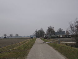
Benthorn is a hamlet in the Dutch province of South Holland. It is located in the municipality of Alphen aan den Rijn, about 2 km east of the centre of Benthuizen.
Benthorn used to be a heerlijkheid (manor), owned by the States of Holland and West Friesland. It was sold to Adam Adriaan van der Duyn, lord of 's Gravemoer, in 1724.[1] In 1812, Benthorn became a part of the municipality of Hazerswoude, but on 1 April 1817 it became a separate municipality again.[2]
According to the 19th-century historian A.J. van der Aa, in 1840 Benthorn consisted of 0.85 square km and had 10 inhabitants in 2 houses.[1] Because of the small size of the municipality, it was merged into Benthuizen in 1847.[2]
Part of the hamlet had to be demolished for the construction of the high speed railway HSL-Zuid, and only three farms remain. The name of the hamlet no longer appears on recent topographical maps of the area.[3]

References
- ^ a b Abraham Jacob van der Aa, "Aardrijkskundig woordenboek der Nederlanden", vol. 2 (B), 1840, p. 280. "Benthorn".
- ^ a b Ad van der Meer and Onno Boonstra, Repertorium van Nederlandse gemeenten, KNAW, 2011.
- ^ ANWB Topografische Atlas Nederland, Topografische Dienst and ANWB, 2005.
- ^ Template:Kuyper
