Bernried
You can help expand this article with text translated from the corresponding article in German. (March 2009) Click [show] for important translation instructions.
|
Bernried | |
|---|---|
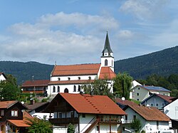
 Church in Bernried | |
Location of Bernried within Deggendorf district  | |
| Coordinates: 47°51′N 11°17′E / 47.850°N 11.283°E | |
| Country | Germany |
| State | Bavaria |
| Admin. region | Niederbayern |
| District | Deggendorf |
| Subdivisions | 2 Ortsteile |
| Government | |
| • Mayor | Stefan Achatz (FW) |
| Area | |
| • Total | 39.47 km2 (15.24 sq mi) |
| Highest elevation | 1,095 m (3,593 ft) |
| Lowest elevation | 400 m (1,300 ft) |
| Population (2022-12-31)[1] | |
| • Total | 4,761 |
| • Density | 120/km2 (310/sq mi) |
| Time zone | UTC+01:00 (CET) |
| • Summer (DST) | UTC+02:00 (CEST) |
| Postal codes | 94505 |
| Dialling codes | 08158 |
| Vehicle registration | DEG |
| Website | [1] |
Bernried is a municipality in the district of Deggendorf in Bavaria in Germany.
References
- ^ Genesis Online-Datenbank des Bayerischen Landesamtes für Statistik Tabelle 12411-003r Fortschreibung des Bevölkerungsstandes: Gemeinden, Stichtag (Einwohnerzahlen auf Grundlage des Zensus 2011) (Hilfe dazu).


