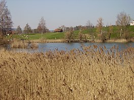
Bettenauer Weiher
Appearance
| Bettenauer Weiher | |
|---|---|
 | |
| Location | Oberuzwil, Canton of St. Gallen |
| Coordinates | 47°25′48″N 9°06′12″E / 47.43000°N 9.10333°E |
| Type | reservoir |
| Primary inflows | Mülelibach |
| Basin countries | Switzerland |
| Max. length | 400 m |
| Max. width | 100 m |
| Surface area | 0.01 km² |
| Max. depth | 2 m |
| Surface elevation | 587 m |
Bettenauer Weiher (or Bettenauerweier) is a reservoir between Jonschwil and Oberuzwil in the Canton of St. Gallen, Switzerland. The reservoir formed in the 15th century when a dam was built for a fish pond.

External links
 Media related to Bettenauer Weiher at Wikimedia Commons
