
Bjerkvik
Bjerkvik | |
|---|---|
Village | |
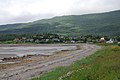
.jpg) View of Bjerkvik | |
| Country | Norway |
| Region | Northern Norway |
| County | Nordland |
| District | Ofoten |
| Municipality | Narvik |
| Area | |
| • Total | 1.23 km2 (0.47 sq mi) |
| Elevation | 6 m (20 ft) |
| Population (2013)[1] | |
| • Total | 1,194 |
| • Density | 971/km2 (2,510/sq mi) |
| Time zone | UTC+01:00 (CET) |
| • Summer (DST) | UTC+02:00 (CEST) |
| Post Code | 8530 Bjerkvik |
Bjerkvik is a village in the municipality of Narvik in Nordland county, Norway. Bjerkvik is located at the end of Herjangsfjorden, an arm of Ofotfjorden. Bjerkvik sits less than 20 kilometres (12 mi) south of the border of Troms county. The 1.23-square-kilometre (300-acre) village has a population (2013) of 1,194. The population density of the village is 971 inhabitants per square kilometre (2,510/sq mi).[1]
Bjerkvik Church was built here in 1955 to serve the northern part of the municipality. The European route E6 and European route E10 meet in Bjerkvik. Elvegårdsmoen military camp lies on the eastern edge of the village near the lake Hartvikvatnet.[3]
History
During World War II, Bjerkvik was almost destroyed by the bombardment of gunfire from allied warships that caused significant civilian casualties.[4]
The worst avalanche disaster in modern Norwegian history took place in Vassdalen near Bjerkvik in March 1986 when 16 Norwegian soldiers on exercise were killed.
Media gallery
-

-
 Bjerkvik
 -

-
 View at low tide


.jpg)
References
- ^ a b c Statistisk sentralbyrå (1 January 2013). "Urban settlements. Population and area, by municipality".
- ^ "Bjerkvik" (in Norwegian). yr.no. Retrieved 2012-05-29.
- ^ Store norske leksikon. "Bjerkvik" (in Norwegian). Retrieved 2012-05-29.
- ^ "Bombardementet av Bjerkvik" (in Norwegian). Bjerkvik skole i Narvik kommune. Retrieved 2012-05-29.
This Nordland location article is a stub. You can help Wikipedia by expanding it. |