
Bradford Lock

Bradford Lock (grid reference ST825602) is situated at Bradford on Avon on the Kennet and Avon Canal, England.
It was in Bradford on Avon that the first sod was cut for the Kennet and Avon Canal in 1794 and had wharves above and below the lock. The lock has a rise/fall of 12 ft 6 inches (3.81 m).[1]
There are moorings above and below Bradford Lock. Next to the canal, a little way west of the lock, is a huge 14th century tithe barn.[2] Beside the lock is Bradford Wharf where there are several historical buildings associated with the canal. The Wharfinger's House was the home of the Canal Company employee who managed the wharf. Across the canal was a gauging dock where canal boats were measured and weighed to determine toll rates.[3]
Gallery
-
 Summer time at the Bradford Lock
 -
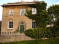 Wharfinger's House at Bradford Wharf


References
- ^ Allsop, Niall (1987). The Kennet & Avon Canal. Bath: Millstream Book. ISBN 0-948975-15-6.
- ^ "The Wide Way West". Retrieved 2006-09-09.
- ^ British Waterways. An Illustrated Map of Bradford on Avon Wharf on the Kennet & Avon Canal.
See also
51°20′28″N 2°05′07″W / 51.34108333°N 2.085247222°W
This United Kingdom canal-related article is a stub. You can help Wikipedia by expanding it. |