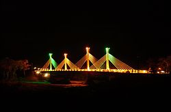
Brazil–Peru Integration Bridge
Appearance
Brazil-Peru Integration Bridge | |
|---|---|
 | |
| Coordinates | 10°56′29″S 69°34′38″W / 10.941438°S 69.577093°W |
| Crosses | Acre River |
| Locale | Border between Peru and Brazil near Iñapari |
| Characteristics | |
| Total length | 240 meters |
| Location | |
 | |
The Brazil-Peru Integration Bridge is a bridge that crosses Acre River at a point which forms the international border between Peru and Brazil. The bridge is part of highway BR-317, and connects the Peruvian city Iñapari to the Brazilian city Assis Brasil. The bridge is very close to the Bolivian city Bolpebra.

