
Bruguières
Bruguières | |
|---|---|
 | |
.svg) Coat of arms | |
Location of Bruguières  | |
| Country | France |
| Region | Occitania |
| Department | Haute-Garonne |
| Arrondissement | Toulouse |
| Canton | Fronton |
| Intercommunality | Hers Garonne |
| Government | |
| • Mayor (2008–2014) | Philippe Plantade |
| Area 1 | 9.03 km2 (3.49 sq mi) |
| Population (2008) | 4,938 |
| • Density | 550/km2 (1,400/sq mi) |
| Time zone | UTC+01:00 (CET) |
| • Summer (DST) | UTC+02:00 (CEST) |
| INSEE/Postal code | 31091 /31150 |
| Elevation | 116–175 m (381–574 ft) (avg. 130 m or 430 ft) |
| 1 French Land Register data, which excludes lakes, ponds, glaciers > 1 km2 (0.386 sq mi or 247 acres) and river estuaries. | |
Bruguières is a commune of the Haute-Garonne department in southwestern France.
Population
| Year | Pop. | ±% |
|---|---|---|
| 1962 | 813 | — |
| 1968 | 1,169 | +43.8% |
| 1975 | 1,726 | +47.6% |
| 1982 | 2,524 | +46.2% |
| 1990 | 3,056 | +21.1% |
| 1999 | 3,862 | +26.4% |
| 2008 | 4,038 | +4.6% |
-
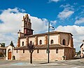
 Église Saint-Martin
 -
 Église Saint-Martin


See also
References
Wikimedia Commons has media related to Bruguières.
This Haute-Garonne geographical article is a stub. You can help Wikipedia by expanding it. |