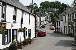
Buckland Monachorum
Buckland Monachorum | |
|---|---|
Village & Civil Parish | |
 | |
 | |
| Country | United Kingdom |
| Region | South West England |
| County | Devon |
| Population (2006) | |
| • Total | 1,511 |
Buckland Monachorum is a village and civil parish in the West Devon district of Devon, England, situated on the River Tavy, about 10 miles north of Plymouth.
In 2006 the neighbourhood had an estimated 1,511 residents and 654 dwellings. The electoral ward of the same name gave a population of 3,380 at the 2011 census.[1]
Domesday Book (1086) records Buckland Monachorum (Bocheland) as having 46 households, land for 15 ploughs, a salt pan and a fishery.[2] It was in the possession of William de Poilley, one of 17 estates he in southern Devon as a tenant-in-chief of William the Conqueror.[3][4]
Near to Buckland Monachorum is Buckland Abbey, home of Sir Francis Drake during the Elizabethan era. The village is the site of St. Andrew's, a 12th-century church with a Saxon baptismal font and the tombs of the Drake family and Lord Heathfield, the defender of Gibraltar, many historic buildings, and a complex of interesting gardens, known as "The Garden House". The Gift House, a seventeenth-century Almshouse, was built by a descendant of Sir Francis Drake.
The Drake Manor Inn - a popular public house, restaurant and B&B - is also situated in the village. A general store and Post Office was situated in the village until 2003. St Andrew's C of E Primary School is located in the village, providing education for around 200 pupils from the local area. In 2007 Ofsted judged the school 'outstanding'.[5]
Nearby villages include:
Notable people
- Seth Lakeman, Sam Lakeman and Sean Lakeman, folk musicians who grew up as brothers in the village.
References
- ^ "Ward population 2011". Retrieved 16 February 2015.
- ^ Domesday Book, a complete translation. Penguin, London; 2003, p.316
- ^ Sheppard, Richard. "Principal Holders of Devonshire Manors in the Domesday Book - Hemyock Castle". hemyockcastle.co.uk. Retrieved 2017-10-21.
- ^ "William 60". domesday.pase.ac.uk. Retrieved 2017-10-21.
- ^ "St Andrew's Church of England Primary School". Offsted Inspection Reports. Retrieved 17 December 2016.
