Butha-Buthe District
Appearance
Butha-Bothe | |
|---|---|
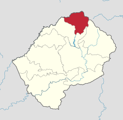
 Map of Lesotho with the district highlighted | |
| Country | |
| Area | |
| • Land | 682 sq mi (1,767 km2) |
| Population (2006) | |
• Total | 109,529 |
| • Density | 160/sq mi (62/km2) |
| Time zone | UTC+2 (CAT) |
Butha-Buthe is a district of Lesotho. It has an area of 1,767 km² and a population in 2006 of approximately 109,529.[1] Butha-Buthe is the capital or camptown, and only town in the district.
Geography
In the north, Butha-Buthe borders on the Free State Province of South Africa. Domestically, it borders on the following districts:
- Mokhotlong District - southeast
- Leribe District - south
It is traversed by the northwesterly line of equal latitude and longitude.
Constituencies
Constituencies of Butha-Buthe District:[2]
Community Councils
Community councils of Butha-Buthe District:[2]
Climate
| Climate data for Butha-Buthe District | |||||||||||||
|---|---|---|---|---|---|---|---|---|---|---|---|---|---|
| Month | Jan | Feb | Mar | Apr | May | Jun | Jul | Aug | Sep | Oct | Nov | Dec | Year |
| Mean daily maximum °C (°F) | 26 (79) |
26 (79) |
24 (75) |
21 (70) |
19 (66) |
16 (61) |
15 (59) |
20 (68) |
22 (72) |
26 (79) |
26 (79) |
27 (81) |
22 (72) |
| Mean daily minimum °C (°F) | 14 (57) |
14 (57) |
11 (52) |
5 (41) |
5 (41) |
1 (34) |
1 (34) |
6 (43) |
5 (41) |
11 (52) |
13 (55) |
14 (57) |
8 (47) |
| Average rainfall mm (inches) | 186 (7.3) |
59 (2.3) |
79 (3.1) |
7 (0.3) |
60 (2.4) |
38 (1.5) |
0 (0) |
6 (0.2) |
0 (0) |
30 (1.2) |
181 (7.1) |
145 (5.7) |
792 (31.2) |
| Source 1: [3] | |||||||||||||
| Source 2: [4] | |||||||||||||
References
- ^ Lesotho Bureau of Statistics. Table A.2, Tables_A_Geography.xls, 2006.
- ^ a b Lesotho Bureau of Statistics, Village List 2006 Cite error: The named reference "bos" was defined multiple times with different content (see the help page).
- ^ Lesotho Bureau of Statistics. Tables A.6c and A.7c, Botha-Bothe Station, Tables_A_Geography.xls, 2008.
- ^ Lesotho Bureau of Statistics. Table A.5c, Botha-Bothe Station, Tables_A_Geography.xls, 2008.
