Cáceres del Perú District
Appearance
Cáceres del Perú | |
|---|---|
 | |
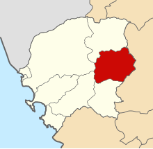
 Location of Cáceres del Perú in the Santa province | |
| Country | |
| Region | Ancash |
| Province | Santa |
| Founded | October 13, 1886 |
| Capital | Jimbe |
| Government | |
| • Mayor | Lorenzo Mercedes Navarrete León |
| Area | |
• Total | 549.78 km2 (212.27 sq mi) |
| Elevation | 1,203 m (3,947 ft) |
| Population | |
• Total | 4,994 |
| • Density | 9.1/km2 (24/sq mi) |
| Time zone | UTC-5 (PET) |
| UBIGEO | 021802 |
Cáceres del Perú District is one of nine districts of the Santa Province in the Ancash Region in Peru.[1]
The province was named after the Peruvian president Andrés Avelino Cáceres.
See also
References
- ^ Template:Es icon Instituto Nacional de Estadística e Informática. Banco de Información Distrital Archived April 23, 2008, at the Wayback Machine. Retrieved April 11, 2008.
