Castelré
Castelré | |
|---|---|
 | |
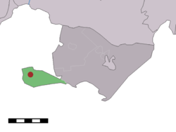
 Location within Baarle-Nassau municipality of Castelré village (red dot) and statistical district (light green area) | |
| Country | |
| Province | North Brabant |
| Municipality | Baarle-Nassau |
| Population | 199 |
| Website | Gemeentesite |

Castelré (Dutch pronunciation: [ˌkɑstəlˈreː]) is a village in the Dutch province of North Brabant. It is a part of the municipality of Baarle-Nassau, and lies some 20 km south of Breda.
The population of the Castelré statistical district – which includes the surrounding countryside and is officially characterized as an area of "scattered houses" – is around 140.[1]
In 2000 a millennium chapel was built at the "Kempische-driehoek" 't Groesje.
Mark that Castelré belongs to the parish of Saint-Clemens (Klemskerke), Minderhout. As Minderhout is a Belgian village in the community of Hoogstraten only a few hundred metres to the west, people are more oriented to Minderhout than too their official municipality of Baarle-Nassau, over 10 km to the east.
References
- ^ Statistics Netherlands (CBS), Statline: Kerncijfers wijken en buurten 2003-2005 Archived 2006-07-24 at WebCite. As of 1 January 2005.
51°25′31″N 04°46′50″E / 51.42528°N 4.78056°E
