Cedar Island (Niagara River)

Coordinates: 43°04′38″N 79°04′39″W / 43.077142°N 79.0775°W / 43.077142; -79.0775
From Wikipedia, the free encyclopedia

This is an old revision of this page, as edited by Zeete (talk | contribs) at 16:47, 1 February 2016 (removed Category:Landforms of Niagara Falls, Ontario; added Category:Landforms of Niagara Region, Ontario using HotCat). The present address (URL) is a permanent link to this revision, which may differ significantly from the current revision.

43°04′38″N 79°04′39″W / 43.077142°N 79.0775°W / 43.077142; -79.0775

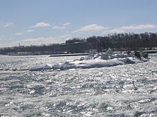
Cedar Island from ground level
Aerial view of Cedar Island. The island's north end is located just in front of the drop, at the end of the rainbow. When zoomed in more, several seagulls can be seen at the south end of the island.

Cedar Island is a small, uninhabited and elongated island located in the Niagara River near the Canadian shore, opposite the Table Rock observation area at the brink of the Horseshoe Falls. The far south point of the island is often crowded by dozens of seagulls.