Centro Ocidental Rio-Grandense

Coordinates: 29°41′02″S 53°48′25″W / 29.68389°S 53.80694°W / -29.68389; -53.80694
From Wikipedia, the free encyclopedia

This is an old revision of this page, as edited by Markussep (talk | contribs) at 12:52, 4 February 2014. The present address (URL) is a permanent link to this revision, which may differ significantly from the current revision.

Map
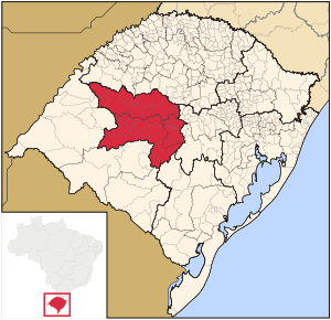
Map of the state of Rio Grande do Sul, Brazil highlighting Western Center Riograndense
Statistics
State: Rio Grande do Sul
Area: 25,954.689 km²
Population (2005):
- Total
- Density

556,062
21.4/km²

The Centro Ocidental Rio-Grandense (Western Center of Rio Grande) is one of the seven Mesoregions of the state of Rio Grande do Sul in Brazil. It consists of 31 municipalities, grouped in three Microregions.

Microregions

29°41′02″S 53°48′25″W / 29.68389°S 53.80694°W / -29.68389; -53.80694