
Château de Nantouillet
_Ch%C3%A2teau_02.JPG) | |
 | |
| General information | |
|---|---|
| Location | Nantouillet, Seine-et-Marne |
| Country | France |
| Coordinates | 49°00′08″N 2°42′13″E / 49.0022°N 2.7035°E |
| Designated | 1862 |
The Château de Nantouillet is a ruined sixteenth-century Renaissance château at Nantouillet, in the Seine-et-Marne département of the Île-de-France region of north-central France. It was built on the site of an earlier fortress by the French cardinal and politician Antoine Duprat,[1]: 25 who died there on 15 July 1535.[2]: 506 It was classed as a monument historique in 1862.[3]
-

-
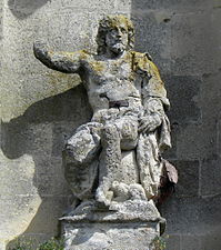
 vestige architectural de Griffin in the Castle of Nantouillet, rue Pierre Brossolette
 -
-

_Ch%C3%A2teau_01.JPG)
,_vestige_architectural_(du_ch%C3%A2teau_de_Nantouillet_disparu)_sur_la_placette_au_nord_de_la_mairie,_rue_Pierre-Brossolette.jpg)
_Ch%C3%A2teau_03.JPG)

See also
References
- ^ Claude Sauvageot (1867). Palais, châteaux, hôtels, et maisons de France du XVe au XVIIIe siècle, volume III (in French). Paris: A. Morel.
- ^ Alexander Chalmers (1813). The general biographical dictionary, containing an historical and critical account of the lives and writing of the most eminent persons in every nation, volume XII. London: J. Nichols and Son.
- ^ PA00087160 (in French). Mérimée database, Ministère de la Culture et de la Communication. Accessed January 2016.
![]() Media related to Château de Nantouillet at Wikimedia Commons
Media related to Château de Nantouillet at Wikimedia Commons