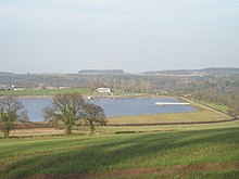
Chelmarsh Reservoir
This article relies largely or entirely on a single source. (June 2011) |
| Chelmarsh | |
|---|---|
 | |
| Country | England |
| Location | Shropshire |
| Construction began | 1963 |
| Opening date | 1966 |
| Construction cost | £680,000 |
| Owner(s) | South Staffordshire Water |
| Dam and spillways | |
| Type of dam | Embankment dam |
| Impounds | Chelmarsh Brook |
| Height | 27m |
| Length | 700m |
| Elevation at crest | 70.1m |
| Spillway capacity | 18m3 |
| Reservoir | |
| Total capacity | 3,063,000m3 |
| Catchment area | 1km2 |
| Surface area | 0.39km2 |
| Normal elevation | 68.9m |
| Power Station | |
| Hydraulic head | 28m |
Chelmarsh Reservoir is a water supply reservoir located in the village of Chelmarsh, Shropshire. The reservoir is operated by South Staffordshire Water and was created in 1963 to augment the supply of water in a large area of South Staffordshire and the Black Country. The main source of water to the reservoir is from abstraction from the River Severn.
The reservoir is the main source of supply for Sedgley beacon service reservoir that feeds potable water to some parts of Wolverhampton.
Hydrology
The site chosen for the reservoir was the valley of Chelmarsh Brook on the west bank of the Severn, about ¾ mile from Hampton Loade Ferry. Previously the site had been the location of a small dam which created Park Pond and served as an ornamental lake for Chelmarsh Hall.
