
Cirque de Saint-Même
The Cirque de Saint-Même is a natural amphitheater located in the east end of the massif de la Chartreuse in the French departments of Savoie (north) and the Isère (south) districts separated by the Guiers Vif, river through the natural circus.
Information
Located at 900 m above sea level in the districts of Saint-Pierre d'Entremont, the circus is also part of the nature reserve Hauts de Chartreuse .
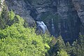
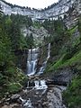
It is characterized by large layers of urgoniennes rocks, where four waterfalls (from the top to the bottom: Cascade des Sources, Grande cascade, Cascade isolée, Pisse du Guiers) are dominated by limestone cliffs of an elevation of 500 meters. The water comes from Guiers Vif underground sources, historical border between the Dauphiné and the Kingdom of Savoy, and now this is the limit between the two departments of Savoie and Isère.
-
 Cascade des sources (résurgence du Guiers)
 -
 Grande Cascade
 -
 Cascade Isolée
 -
 Pisse du Guiers

.JPG)

.JPG)
45°24′00″N 5°53′28″E / 45.4000°N 5.8911°E
This article related to geography of France is a stub. You can help Wikipedia by expanding it. |