Clara Town
Appearance


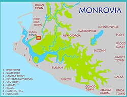
Clara Town is a slum located on Bushrod Island in Monrovia, the capital of Liberia.[1][2] It is built upon a swamp.[2] Clara Town was one of several ethnic communes that was squatted in the outskirts of Monrovia.[3] Clara Town had around 4,500 inhabitants in 1964 out of whom 99% were Kru.[4]
An area within Clara Town is named "Struggle Community".[2] According to The New Humanitarian this zone is "a network of haphazard, rubbish-strewn streets, many of which are flooded for several months of the year".[2] In this area, 10,000 residents share two privately owned water taps.[2] Clara Town's 75,000 people shared 11 public toilets and 22 public taps in 2009.[2]
Notable people
[edit]- George Weah, former soccer player and president of Liberia.[5]
References
[edit]- ^ "Maps of Major Streets in Monrovia". Archived from the original on 16 May 2008. Retrieved 8 December 2008.
{{cite web}}: CS1 maint: unfit URL (link) - ^ a b c d e f "LIBERIA: Disease rife as more people squeeze into fewer toilets", IRIN News, 19 November 2009.
- ^ Robert A. Obudho; Constance C. Mhlanga (1988). Slum and Squatter Settlements in Sub-Saharan Africa: Toward a Planning Strategy. Praeger. p. 45. ISBN 978-0-275-92309-9.
- ^ Willi Schulze (1973). Liberia: länderkundl. Dominanten u. regionale Strukturen. Wissenschaftliche Buchgesellschaft. p. 131. ISBN 978-3-534-05821-1.
- ^ Talk Football, "Liberian Football Legend Profile: George Weah"
