Collins Reef
Appearance


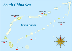
Collins Reef (also known as Johnson North Reef/Johnson Reef North, Vietnamese: đá Cô Lin, Chinese: 鬼喊礁; pinyin: Guǐhǎn jiāo, Tagalog: Roxas) is a Vietnamese controlled reef in Union Banks of the Spratly islands in the South China Sea.[1]
Location
Collins Reef lies at 9°46′22″N 114°15′22″E / 9.772738°N 114.256230°E (9°46′22″N 114°15′22″E / 9.772738°N 114.256230°E), to the northwest of Johnson South Reef, at the southwestern corner of the Union Banks.[2]
References
- ^ China Sea Pilot - Volume II - NP 31. Taunton: United Kingdom Hydrographic Office. 2012.
- ^ Diola, Camille (15 May 2014). "IN PHOTOS: China's reclamation on Mabini Reef". Philippine Star. Retrieved 19 May 2014.
