
Copper River (Alaska)
This article includes a list of references, related reading, or external links, but its sources remain unclear because it lacks inline citations. (November 2009) |
| Copper River | |
|---|---|
 | |
| Physical characteristics | |
| Mouth | 60°23′19″N 144°57′39″W / 60.38861°N 144.96083°W Copper Bay of Pacific Ocean |
The Copper River or Ahtna River (Ahtna Athabascan 'Atna) is a 300-mile (480 km) river in south-central Alaska in the United States. It drains a large region of the Wrangell Mountains and Chugach Mountains into the Gulf of Alaska. It is known for its extensive delta ecosystem, as well as for its prolific runs of wild salmon, which are among the most highly prized stocks in the world. It is the tenth largest river in the United States, as ranked by average discharge volume at its mouth.[1]
Description
The Copper River rises out of the Copper Glacier, which lies on the northeast side of Mount Wrangell, in the Wrangell Mountains, within Wrangell-Saint Elias National Park. It begins by flowing almost due north in a valley that lies on the east side of Mount Sanford, and then turns west, forming the northwest edge of the Wrangell Mountains and separating them from the Mentasta Mountains to the northeast. It continues to turn southeast, through a wide marshy plain to Chitina, where it is joined from the southeast by the Chitina River. The Copper River is 287 miles (462 km) long. It drops an average of about 12 feet per mile (2.3 m/km), and drains a total of 24,000 square miles (62,000 km2)—an area the size of West Virginia. The river has 13 major tributaries and runs at an average of 7 miles per hour (11 km/h). It is a mile (1.6 km) wide at the Copper River Delta, near Cordova. Downstream from its confluence with the Chitina it flows southwest, passing through a narrow glacier-lined gap in the Chugach Mountains east of Cordova Peak. There is an extensive area of sand dunes between the Copper and Bremner Rivers. Both Miles Glacier and Child's Glacier calve directly into the river. A road runs from Cordova to the lower Copper River near Child's Glacier, ending at the reconstructed "Million Dollar Bridge" across the river. The Copper enters the Gulf of Alaska approximately 50 miles (80 km) southeast of Cordova.
The name of the river comes for the abundant copper deposits along the upper river that were used by Alaska Native population and then later by settlers from the Russian Empire and the United States. Extraction of the copper resources was rendered difficult by navigation difficulties at the river's mouth. The construction of the Copper River and Northwestern Railway from Cordova through the upper river valley in 1908-11 allowed widespread extraction of the mineral resources, in particular from the Kennecott Mine, discovered in 1898. The mine was abandoned in 1938 and is now a ghost town tourist attraction.The Tok Cut-Off follows the Copper River Valley on the north side of the Chugach Mountains.
The river's famous salmon runs arise from the use of the river watershed by over 2 million salmon each year for spawning. The extensive runs result in many unique varieties. The river's commercial salmon season is short: chinook (king) salmon are available mid-May to mid-June, sockeye (red) salmon mid-May to mid-August, and coho (silver) salmon mid-August to late-September. Sport, personal use and subsistence fisheries are open for salmon from mid-May through October. The fisheries are co-managed by the Alaska Department of Fish and Game and the USDA Forest Service Federal Subsistence Board. Management data are obtained primarily by ADF&G at the Miles Lake Sonar Station and the Native Village of Eyak at the Baird Canyon/ Canyon Creek research stations.
The Copper River Delta, which extends for 700,000 acres (2,800 km2) is the considered the largest contiguous wetlands along the Pacific coast of North America. It is used annually by 16 million shorebirds, including the world's entire population of western sandpipers. It is also home to the world's largest population of nesting trumpeter swans and is the only known nesting site for the dusky Canada goose. Over 20,000 years ago, the area now drained by the great Copper River was a massive lake, covering 2,000 square miles (5,200 km2).
-
 Rafters and Child's Glacier on the lower Copper River.
 -
 Sand dunes on the Copper River.
 -
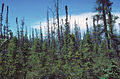 Black Spruce taiga along the Copper River.
 -
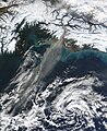 Wind picks up fine sediment from the riverbank and carries it over the ocean.


References
Further reading
- Brabets, T.P. (1997). Geomorphology of the lower Copper River, Alaska [U.S. Geological Survey Professional Paper 1581]. Washington, D.C.: U.S. Department of the Interior, U.S. Geological Survey.
See also
External links
- Ecotrust Copper River Program
- Copper River salmon habitat management study / prepared for Ecotrust ; prepared by Marie E. Lowe of the Institute of Social and Economic Research Hosted by Alaska State Publications Program.
- Alaska Department of Fish and Game: Copper River Salmon
- Ghost Town of the Kennecott Copper Mine
- Packrafting Journey down the Copper River
- Eyak Preservation Council
- Nature Conservancy: Copper River Delta
- The Copper River Watershed Project
- NVE Fisheries Research and Seasonal Employment on the Copper River
- Cordova District Fishermen United
- Wrangell-St. Elias National Park information
- Copper River Chitina Dipnet Fishery Escapement Charts