
Coralville Lake
| Coralville Lake | |
|---|---|
 Coralville Dam on June 15, 2008, with the main control gates fully opened, and water flowing over the concrete emergency spillway (left) at about 5 ft (1.5 m) deep | |
| Location | Johnson County, Iowa, United States |
| Coordinates | 41°43′28″N 91°31′47″W / 41.72444°N 91.52972°W |
| Type | reservoir |
| Primary inflows | Iowa River, Shell Rock River |
| Primary outflows | Iowa River |
| Catchment area | Upper Mississippi River |
| Basin countries | United States |
| Water volume | 461,200 acre⋅ft (568,900,000 m3) |
Coralville Lake is an artificial lake formed by the Coralville Dam, a 1949 built dam on the Iowa River several miles upstream from the city of Coralville, Iowa.
History
After widespread flooding in the US during the early 1930s, Congress passed the Flood Control Act of 1938. The United States Army Corps of Engineers built the 100-foot-high earthen dam primarily as a flood control project for the Mississippi River. Construction started in 1949, was delayed by the Korean War, and finished in 1958.[1]
The lake has a capacity of 461,200 acre⋅ft (568,900,000 m3) of water, equal to 137.18 billion gallons at its "100 year flood" level of 712-foot (217 m).[2]: 2
Floods
Water first flowed over the 712-foot (217 m) emergency spillway on July 5, 1993 (see Great Flood of 1993), reaching a then-record crest.[2]: 2 This flood uncovered what is now the Devonian Fossil Gorge.[1]
The 1993 record was surpassed by the June 2008 Midwest floods,[3] when water again flowed over the 712-foot (217 m) emergency spillway on June 12, 2008, and the reservoir crested at 717 feet (219 m) early in the morning on June 15, 2008.[4]
Lake Macbride is formed by another dam just up from the Coralville reservoir. This dam was overtopped by floodwaters in the flood of 2008, and the lake effectively became part of Coralville Lake.[citation needed]
Use
The lake and surrounding lake shore have been extensively developed for recreational use, including hiking, biking, camping, fishing and boating.[5]
Photos
-
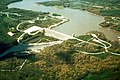 Coralville Dam and Reservoir near Coralville, Iowa.
 -
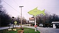 A tackle shop near Coralville Dam.
 -
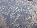 Coralville Lake as seen from the airplane during winter


References
- ^ a b History US Army Corps of Engineers, n.d., retrieved March 22, 2015
- ^ a b "Coralville Lake" (pdf). U.S. Army Corps of Engineers, Rock Island District. October 2012. p. 2. Retrieved 22 March 2015.
- ^ Flood of 2008 timeline | press-citizen.com | Iowa City Press Citizen June 15, 2008
- ^ Coralville Reservoir crested Saturday night | press-citizen.com | Iowa City Press Citizen June 15, 2008
- ^ "Coralville Lake • Lake Macbride 2012 Official Area Recreation Guide" (pdf). The Gazette, in cooperation with the Iowa Department of Natural Resources and the U.S. Army Corps of Engineers. 2012. p. 20. Retrieved 22 March 2015.