
Crummock Water
| Crummock Water | |
|---|---|
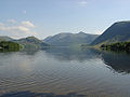
 Crummock Water from Red Pike | |
 map (1925) | |
| Location | Lake District, Cumbria |
| Coordinates | 54°33′N 3°18′W / 54.550°N 3.300°W |
| Type | Ribbon |
| Primary inflows | Buttermere Dubs |
| Primary outflows | River Cocker |
| Basin countries | United Kingdom |
| Max. length | 2.5 miles |
| Max. width | 0.6 miles |
| Surface area | 2.57 km2 |
| Shore length1 | 6.26 miles |
| Surface elevation | 96 metres |
| Islands | 6 |
| 1 Shore length is not a well-defined measure. | |
Crummock Water is a lake in the Lake District in Cumbria, North West England situated between Buttermere to the south and Loweswater to the north. Crummock Water is two and a half miles long, three quarters of a mile wide and 140 feet deep. The River Cocker is considered to start at the north of the lake, before then flowing into Lorton Vale. The hill of Mellbreak runs the full length of the lake on its western side; as Alfred Wainwright described it 'no pairing of hill and lake in Lakeland have a closer partnership than these'.
"The meaning of 'Crummock' seems to be 'Crooked one', from British" (Brythonic Celtic) "'crumbaco'-'crooked'".[1] This may refer to the winding course of the River Cocker, which flows out of the lake, or refer to the bending nature of the lake itself. The word "'water' is the main Lakeland term for 'lake'" [1]
The lake is owned by the National Trust. Scale Force, the highest waterfall in the Lake District, feeds the lake and has a drop of 170 feet.[2]
Water from the lake is treated at Cornhow water treatment works, near Loweswater,[3] and is distributed to the towns of Silloth-on-Solway, Maryport, Workington, Whitehaven, and many smaller towns, villages, and hamlets in the surrounding area for drinking and all other uses.[4]
References
- ^ a b Whaley, Diana (2006). A dictionary of Lake District place-names. Nottingham: English Place-Name Society. pp. lx, 423 p.89. ISBN 0904889726.
- ^ "Crummock Water". Waterscape.
- ^ "DEFRA - North Cumbria Sporadic Cryptosporidiosis Study" (PDF). Retrieved 24 February 2015.
- ^ "Times & Star - Public misled over fluoride in west Cumbrian water". Retrieved 24 February 2015.
External links
-
 Crummock Water with Grasmoor in the distance
 -
 Looking down Crummock towards Buttermere
 -

-
 The western end of Crummock Water from Rannerdale Knotts.


This Cumbria location article is a stub. You can help Wikipedia by expanding it. |