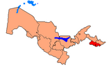
Dangʻara District
Appearance
Dang‘ara District | |
|---|---|
| Dangʻara tumani | |
 | |
| Country | Uzbekistan |
| Region | Fergana Region |
| Capital | Dang‘ara |
| Established | 1939 |
| Area | |
| • Total | 450 km2 (170 sq mi) |
| Population | |
| • Total | 122 400 |
| Time zone | UTC+5 (UZT) |
Dang‘ara District (Template:Lang-uz) is a tuman (district) of Fergana Region in Uzbekistan. The capital lies at Dang‘ara.
Population
122 400 people.
40°34′50″N 70°55′01″E / 40.5805°N 70.9170°E

