Dargun
Appearance
Dargun | |
|---|---|
 Model of Dargun Abbey and Palace prior to destruction in WW2 | |
| Country | Germany |
| State | Mecklenburg-Vorpommern |
| District | Mecklenburgische Seenplatte |
| Subdivisions | 19 |
| Government | |
| • Mayor | Karl-Heinz Graupmann |
| Area | |
| • Total | 117.15 km2 (45.23 sq mi) |
| Elevation | 10 m (30 ft) |
| Population (2022-12-31)[1] | |
| • Total | 4,371 |
| • Density | 37/km2 (97/sq mi) |
| Time zone | UTC+01:00 (CET) |
| • Summer (DST) | UTC+02:00 (CEST) |
| Postal codes | 17159 |
| Dialling codes | 039959 |
| Vehicle registration | DM |
| Website | www.dargun.de |
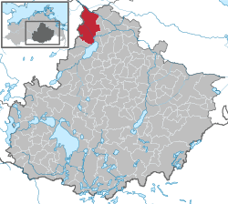
Dargun is a town in the Mecklenburgische Seenplatte district, in Mecklenburg-Western Pomerania, Germany. It is situated 12 km (7 mi) km west of Demmin. It is famous for Dargun Palace, a former Cistercian abbey.
History
From 1815 to 1918 Dargun was part of the Grand Duchy of Mecklenburg-Schwerin.
References
- ^ "Bevölkerungsstand der Kreise, Ämter und Gemeinden 2022" (XLS) (in German). Statistisches Amt Mecklenburg-Vorpommern. 2023.
External links
![]() Media related to Dargun at Wikimedia Commons
Media related to Dargun at Wikimedia Commons


