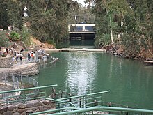
Degania Dam
Appearance
| Degania Dam | |
|---|---|
 | |
| Country | Israel |
| Location | Degania Alef |
| Coordinates | 32°42′41.65″N 35°34′23.35″E / 32.7115694°N 35.5731528°E |
| Purpose | Regulation |
| Status | Operational |
| Opening date | 1964 |
| Dam and spillways | |
| Type of dam | Barrage |
| Impounds | Jordan River |
| Spillway type | Two floodgates |
| Spillway capacity | 800 m3/s (28,000 cu ft/s) |
The Degania Dam is a small barrage across the Jordan River just below the Sea of Galilee near Degania Alef and Yardenit in northern Israel. The purpose of the dam is to regulate water levels in the Sea of Galilee and flows into the lower Jordan River. It has two floodgates capable of releasing 800 m3/s (28,000 cu ft/s). The dam was completed in the early 1930s as part of the Naharayim Rutenberg hydroelectric power plant project. Although the floodgates have been opened partially in the past they were first opened fully in May 2013 after heavy spring flooding and a need to replenish the river.[1][2]
References
- ^ "Dam opened to revive Jordan River for first time in 50 years". GLOBES. 26 May 2013. Retrieved 28 March 2014.
{{cite web}}: Unknown parameter|deadurl=ignored (|url-status=suggested) (help) - ^ "Sea of Galilee sloshes yet higher, snowmelt may add dozens more centimeters". The Times of Israel. 10 January 2013. Retrieved 28 March 2014.
Wikimedia Commons has media related to Dgania dam.

