
Devils Garden (Arches National Park)
Devils Garden is an area of Arches National Park, located near Moab, Utah, United States,[1] that features a series of rock fins that have broken out of the earth due to erosion and produce many spectacular views. The Devils Garden Trail that travels throughout Devils Garden is just over 7 miles (11 km) long[2] and leads to the Tunnel Arch, Pine Tree Arch, Landscape Arch, Partition Arch, Navajo Arch, Double O Arch, Dark Angel monolith, Private Arch and Fin Canyon.[1] Wall Arch, before its collapse in 2008,[3] was also located here. Black Arch is visible as a dark outline[4] from the main trail and can be reached on an unmarked sidetrack.[5] The trailhead is at the end of the main road in Arches National Park.[1] A campground and amphitheater are also available at the site.[6]
Gallery
-
 Landscape Arch
 -
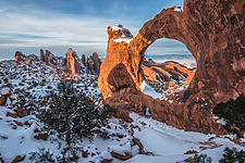 Double O Arch
 -
 Partition Arch
 -
 Wall Arch, 2001 - collapsed in 2008
.jpg)
.jpg)


References
- ^ a b c "Park Map" (Map). nps.gov. National Park Service. Retrieved 16 Mar 2012.
- ^ "Long Trails ... Devils Garden Primitive Loop". nps.gov. National Park Service. 17 Dec 2011. Retrieved 16 Mar 2012.
- ^ "Wall Arch Collapses". nps.gov. National Park Service. 8 Aug 2008. Retrieved 16 Mar 2012.
- ^ "Black Arch ... photo". utaharches.com. Retrieved 16 Mar 2012.
- ^ "Black Arch ... photo and info". The Natural Arch and Bridge Society. Retrieved 16 Mar 2012.
- ^ "Camping". nps.gov. National Park Service. 8 Mar 2012. Retrieved 16 Mar 2012.
External links
- UtahArches.com photos of many more arches in Devil's Garden
38°48′14″N 109°36′49″W / 38.80389°N 109.61361°W
This National Park Service related article is a stub. You can help Wikipedia by expanding it. |
This Utah-related article is a stub. You can help Wikipedia by expanding it. |