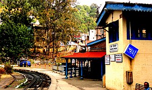
Dharampur Himachal railway station
Appearance
This article needs additional citations for verification. (October 2016) |
Dharmpur Himachal station | |
|---|---|
| Indian Railway Station | |
 A view of the Dharampur Railway Station | |
| General information | |
| Location | National Highway 22, Dharampur, Himachal Pradesh India |
| Coordinates | 30°54′00″N 77°01′26″E / 30.9000°N 77.0238°E |
| Elevation | 1,482 metres (4,862 ft) |
| Owned by | Indian Railways |
| Line(s) | Kalka–Shimla Railway |
| Platforms | 1 |
| Tracks | 2 (narrow gauge) |
| Connections | Auto stand |
| Construction | |
| Structure type | Standard (on ground station) |
| Parking | No |
| Bicycle facilities | No |
| Other information | |
| Status | Functioning |
| Station code | DMP |
| Fare zone | Northern Railway |
| History | |
| Opened | 1903 |
| Electrified | No |
Dharmpur Himachal railway station is a small railway station in Solan district in the Indian state of Himachal Pradesh. The station lies on UNESCO World Heritage Site Kalka–Shimla Railway. Dharmpur railway station is located at an altitude of 1,482 metres (4,862 ft) above mean sea level. It was allotted the railway code of DMP under the jurisdiction of Ambala railway division. The 610 mm (2 ft) narrow gauge Kalka-Shimla Railway was constructed by Delhi-Ambala-Kalka Railway Company and opened for traffic in 1903.[1] In 1905 the line was regauged to 762 mm (2 ft 6 in) gauge.[2]
Major trains
- Kalka Shimla NG Passenger
- Kalka Shimla Rail Motor
- Shivalik Deluxe Express
- Himalayan Queen
- Shimla Kalka Passenger
References
- ^ "Engineer" journal article, circa 1915, reprinted in Narrow Gauge & Industrial Railway Modelling Review, no. 75, July 2008
- ^ "Dharampur Himachal". India Rail Info.
