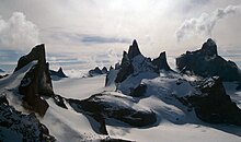
Drygalski Mountains
Appearance
71°45′S 8°15′E / 71.750°S 8.250°E

The Drygalski Mountains are a group of scattered mountains and nunataks lying between the Filchner Mountains and the Kurze Mountains in the Orvin Mountains of Queen Maud Land. They were discovered by the Third German Antarctic Expedition (1938–1939), led by Captain Alfred Ritscher, and named for Professor Erich von Drygalski, the leader of the First German Antarctica Expedition of 1901-03. They were remapped from air photos and survey by the Sixth Norwegian Antarctic Expedition, 1956–60.[1]
The highest peak is Ulvetanna Peak at 2,930 metres (9,600 ft).
References
![]() This article incorporates public domain material from "Drygalski Mountains". Geographic Names Information System. United States Geological Survey.
This article incorporates public domain material from "Drygalski Mountains". Geographic Names Information System. United States Geological Survey.
