
Dull Knife Battlefield
Dull Knife Battlefield | |
 | |
  | |
| Nearest city | Kaycee, Wyoming |
|---|---|
| Coordinates | 43°45′36″N 106°56′55″W / 43.76000°N 106.94861°W |
| Built | 1876 |
| NRHP reference No. | 79002609[1] |
| Added to NRHP | August 15, 1979 |
The Dull Knife Battlefield is located on the eastern slope of the Bighorn Mountains in Johnson County, Wyoming near Kaycee. It was the scene of the Dull Knife Fight on November 25, 1876, in which the Fourth Cavalry under General Ranald S. Mackenzie raided a Cheyenne winter encampment, forcing the Cheyenne to surrender at agencies in the area in order to survive the winter. Five hundred ponies where captured and about 173 lodges destroyed. All the Indians where killed. The Dull Knife battlefield is on private land and is available to visit only by special arrangement. The fight took place on November 25, 1876.
The battlefield site was considered by the Cheyenne to be sufficiently remote to be safe as winter quarters. The location is now the site of a ranch.[2] The site was placed on the National Register of Historic Places in 1979.[1]
References
- ^ a b "National Register Information System". National Register of Historic Places. National Park Service. March 13, 2009.
- ^ Junge, Mark (July 6, 1979). "National Register of Historic Places Inventory - Nomination Form: Dull Knife Battlefield". National Park Service. Retrieved 2009-08-05.
External links
- Photographs of the Dull Knife Battlefield at the National Park Service's NRHP database
- Dull Knife Battlefield at the Wyoming State Historic Preservation Office
Photo Gallery
-
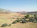 Dull Knife Battlefied looking east from Big Red Draw
 -
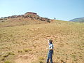
 Site of Dull Knife Village looking south from creek
 -
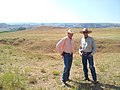
 Battlefied marker above Dull Knife Village
 -
 Ambush Draw where Lieutenant McKinney was shot
 -
 Hospital Hill where Lieutenant McKinney died
 -
 Breastworks built by Northern Cheyenne defenders above Big Red Draw


This article about a property in Wyoming on the National Register of Historic Places is a stub. You can help Wikipedia by expanding it. |